You'll know first.
Before It Strikes warns you minutes — sometimes hours — before lightning strikes, pushes official NWS alerts the instant they're issued, and tells you the exact moment it's safe to go back out. Hi-res 3D radar, nationwide. Free, on iOS.

Free on iOS — nationwide lightning prediction, official NWS warnings, and hi-res 3D radar, available now. Press & partnerships: [email protected]
We saw it coming.
In the June 21, 2026 severe outbreak, we replayed the actual National Weather Service radar and GOES satellite lightning data and measured how far ahead our radar signature appeared before each storm's first lightning strike — across 100 storms over Indiana & Illinois.
Based on a backtest of a single severe outbreak (June 21, 2026), replaying real NWS radar & GOES satellite data across ~100 storms. A backtest of one event — not a guarantee of future performance, and never a substitute for official warnings or lightning-safety guidance.
Zoom past the county line — down to your street.
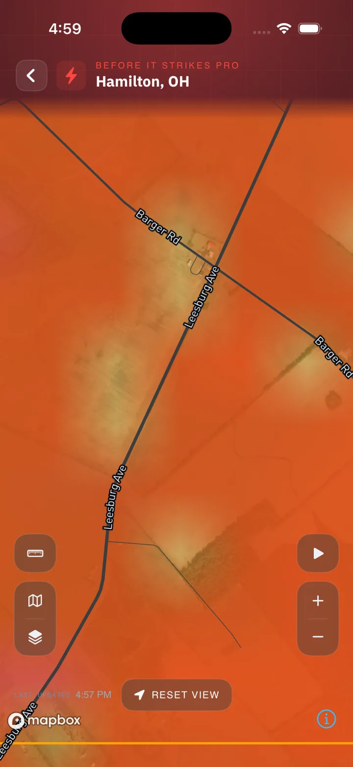
Crisp, GPU-smooth radar you can tilt into 3D and zoom until you see your own block — your buildings, your backyard, your kid's school — with the storm moving right over it. Not a colored blob over your city. Your actual neighborhood.
- High-resolution base reflectivity, buttery smooth
- Tilt into 3D with real buildings & terrain
- Zoom to street level, where building data is available
The sky and the air, in one place.
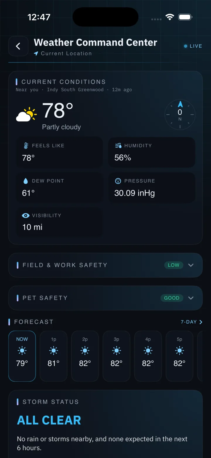
One screen reads everything where you're standing. Full current conditions with a live wind compass, a single 1–5 threat level that fuses official risk, active warnings and live instability, how fast lightning is firing and how close it is — plus safety readouts for heat, cold, work at height, and your dog.
- Detailed conditions — temp, feels-like, humidity, dew point, wind, pressure, visibility
- Fused 1–5 threat level from official risk, warnings & live instability
- Live lightning rate, nearest strike & local storm reports
- Field & Work Safety and Pet Safety, one tap away
The timer that resets with every strike.
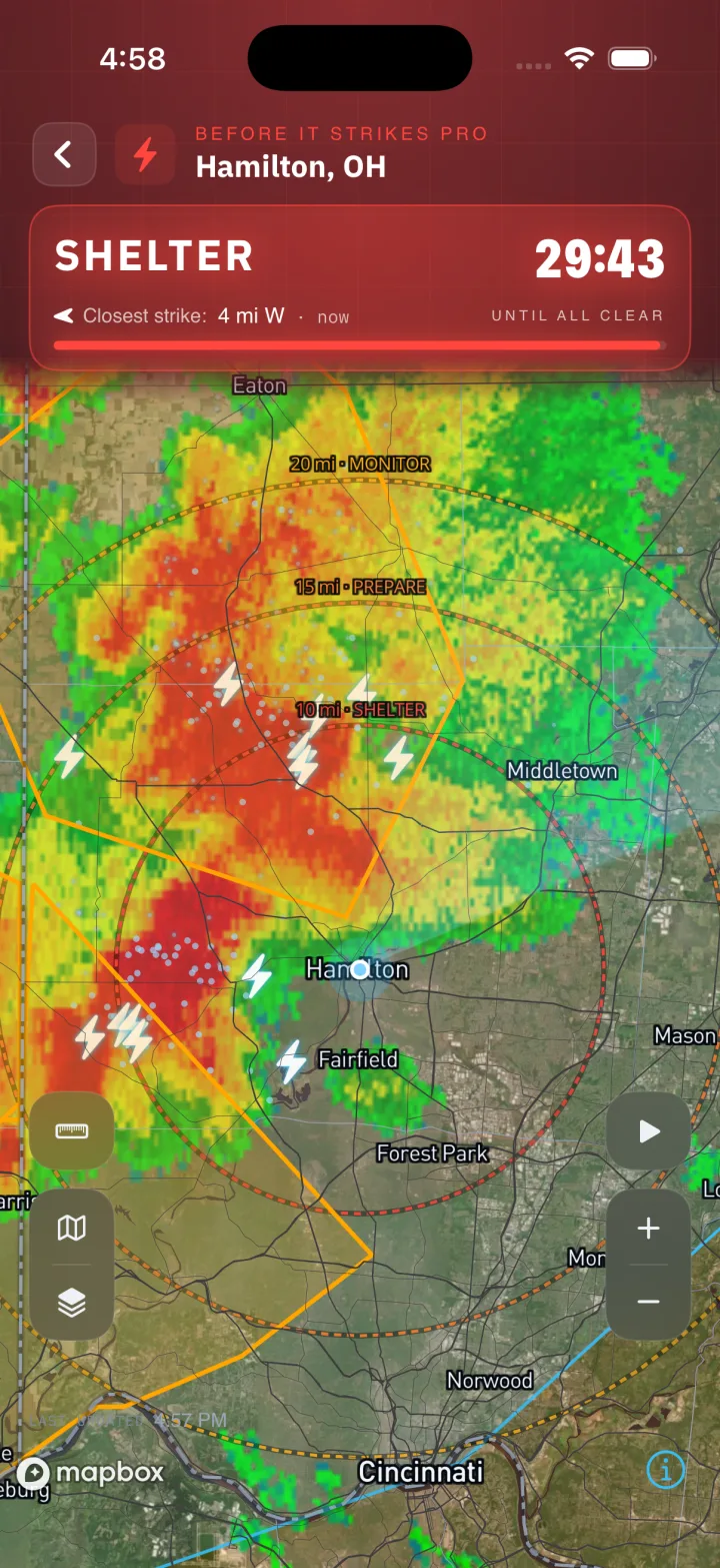
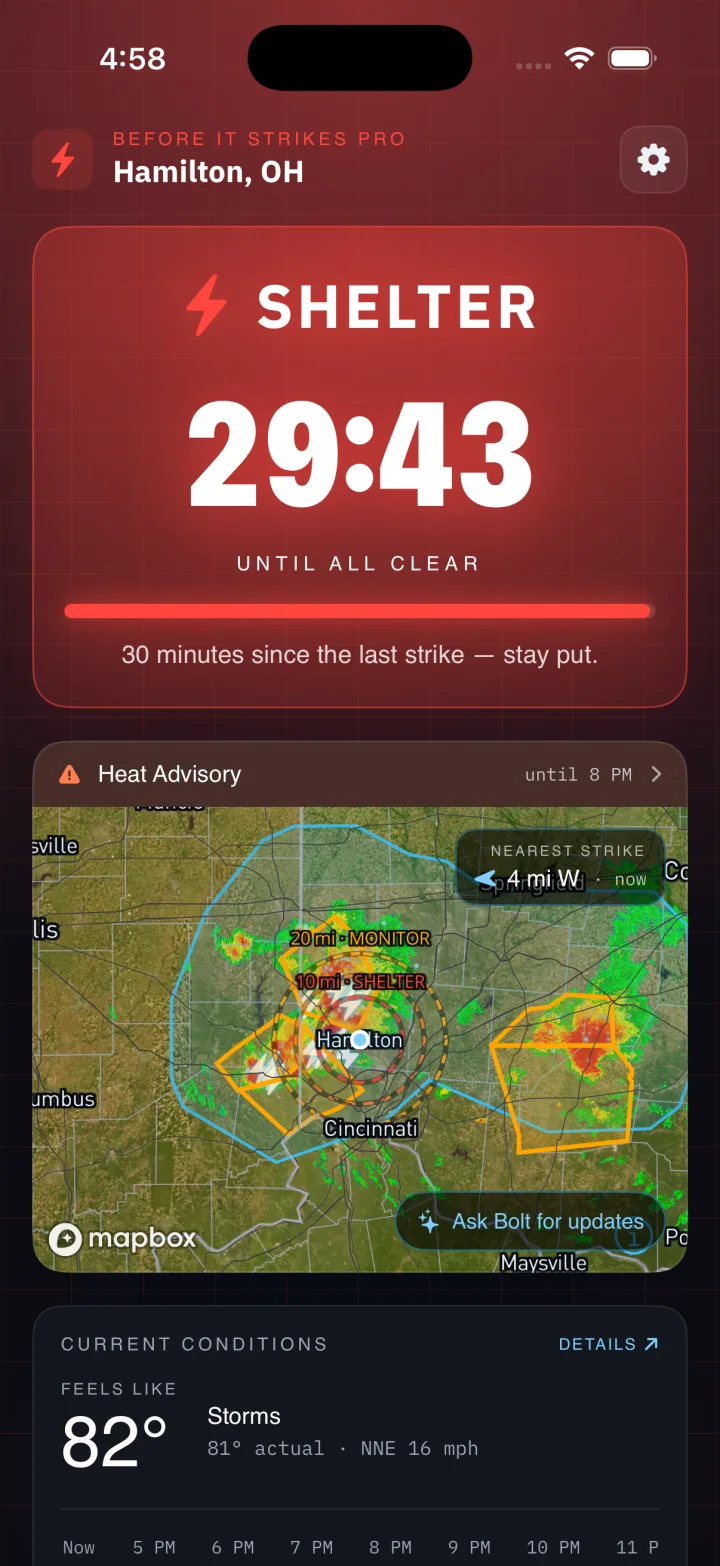
When lightning lands within ten miles, a thirty-minute countdown starts. Every new nearby strike pushes it back to thirty — exactly the 30-30 rule the pros use. When the ring empties, you're genuinely clear. It's motion-aware, so a storm moving away never cries wolf.
- Restarts on every strike within your radius
- Honest "all-clear" — the moment it's actually safe
- Blends observed strikes with forecast guidance
The all-clear, at a glance.
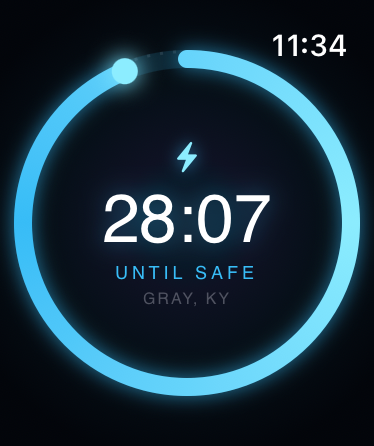
The shelter countdown mirrors straight to your Apple Watch — a glowing ring that drains 30:00 → 0, resetting to thirty with every nearby strike. No phone, no unlocking. Just lift your wrist to know whether it's safe to head back out.
- The same 30-minute all-clear ring, on watchOS
- Restarts on every strike within your radius
- A clean ALL CLEAR the moment the sky settles
The whole warning — in plain English.
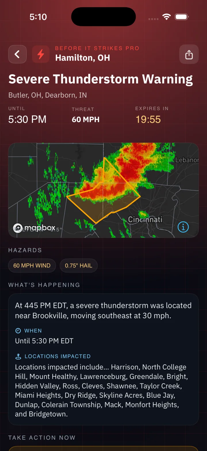
When the National Weather Service issues a warning for a place you've saved, you get all of it — not just a banner. A live expiration countdown, the exact hazard tags, what's actually happening, the one thing to do right now, and every county in the path.
- Live “expires in” countdown on every warning
- Impact-based hazard tags: tornado, wind, hail, flash flood
- Plain-language “take action now” guidance
- Every affected county, listed by name
Mount it. Glance at it. Trust it.
Quick View turns an iPad into a big-screen lightning board: a giant all-clear countdown readable from across the deck, a clear heads-up when lightning is moving in, and live radar underneath. Built for camp directors, pool managers, coaches, and event staff who have to make the call.
- Giant, glanceable all-clear countdown
- "Lightning approaching" the moment it matters
- Animated radar — perfect for a wall-mounted kiosk
Go Pro. However you show up.
One person with a phone, or an organization with a dozen fields — there's a Pro tier that fits how you keep people safe.
$10/mo
$10/month or $75/year · cancel anytime
The most precise lightning we offer — the licensed, ground-based strike feed, right in the app.
Get Before It Strikes Pro- Pinpoint ground-based strikes on your map
- Forecasted all-clear — know when it's safe to head back out
- Bolt-from-the-blue alerts for strikes outside the storm
- Charging-cloud awareness before the first flash
- Bolt, your AI assistant — ask what to do, when it clears, what's coming
Plans that scale with you, not per site.
Draw the areas you watch, put every coach, lifeguard, and parent on the alert list, and mount a live board wherever your people gather. Flat pricing, unlimited members, no hardware to buy — add precise lightning per user as you need it.
Starter
$49/mo
A single organization or venue
Core alerting for one site, getting started.
- Up to 3 monitored areas
- Unlimited members & alert recipients
- Push & email alerts — unlimited
- Green / yellow / red safety tiers
- Live radar operations board
- Venue display mode for wall-mounted screens
- Precise lightning & Bolt AI assistant — $5/mo per user
Standard
$149/mo
One flat base — the whole organization
Everything in Starter, plus unlimited areas and compliance tools.
- Unlimited monitored areas
- Automatic alerts when a warning covers a site
- Immutable alert log for compliance
- Webhook / horn & PA integration
- Priority email support
- Precise lightning & Bolt AI assistant — $5/mo per user
- SMS alerts — usage-based add-on
Enterprise
$999+/mo
Districts & multi-site operations
Everything in Standard, plus enterprise controls and an SLA.
- Dedicated servers
- Dedicated monitoring
- SSO / SAML
- Uptime SLA & priority support
- Dedicated onboarding
- Custom integrations & data export
- Volume & multi-org pricing
Compare: a single incumbent site runs ~$2,200/yr plus hardware — and bills you again for every additional site. One flat plan covers every field, pool, and campus. Save two months with annual billing.
Everything watching the sky for you.
Behind the headline features, Before It Strikes ingests the full National Weather Service product suite — nationwide, in real time.
SPC Convective Outlooks
Categorical & probabilistic severe risk for days 1–3, drawn right on your map.
Watch Boxes
Tornado & severe-thunderstorm watch parallelograms the moment SPC issues them.
Mesoscale Discussions
The forecaster's early read on what's developing — often before watches drop.
Local Storm Reports
Real hail, wind, and flood reports from the field, plotted the instant they're filed.
Follow-Me Alerts
Your location travels with you — alerts track where you actually are, not just home.
Save Every Place
Home, the lake house, the kids' school — watch them all at once.
Radar Rotation
Low-level rotation detection on Doppler velocity — extra eyes on spin-up.
Nationwide & Free
Every county, every radar site, no subscription and no paywall on safety.
From the sky to your pocket, in seconds.
The same authoritative data the professionals use — ingested nationwide, scored against your locations, and delivered the instant it matters.
Ingest
Official feeds — NWS VTEC warnings, SPC outlooks, GOES-GLM satellite lightning, and 150+ WSR-88D radars — the instant they publish.
Analyze
Everything is parsed, cross-referenced against your saved places, and scored — storm cells tracked, threats ranked in real time.
Predict
A blend of radar, satellite and forecast signals combines into a first-strike heads-up and each storm's ETA.
Alert
The one alert that matters reaches your phone, Lock Screen and wrist the second it counts — and stays quiet when it doesn't.
Official NWS alerts, the instant they're issued.
Straight from the National Weather Service VTEC feed — for home, the lake house, the kids' school, anywhere you save. Loud when it counts, silent when it doesn't.
The things people ask first.
Is this a replacement for official NWS warnings?
No — and it never pretends to be. Official National Weather Service warnings are always the source of truth, shown exactly as issued. Our derived layers (lightning risk, storm scoring, rotation detection) are supplemental situational awareness — never a substitute for an official warning or lightning-safety guidance.
How can you warn me before lightning strikes?
We continuously read a blend of radar, satellite and forecast signals for the patterns that tend to precede a storm's first flash. In our backtest that produced an average heads-up of 27 minutes — but it's a heads-up, not a guarantee. When in doubt, seek shelter.
Does it work everywhere in the U.S.?
Yes. Before It Strikes is national by design — every county, every NWS office, and 150+ live WSR-88D radar sites. Save any place, or let it follow wherever you are.
Will it drain my battery?
No. Alerts are push-driven, the Lock Screen countdown uses the system Live Activity timer, and background updates are lightweight. You get the watching without the battery cost.
Is there an Apple Watch app?
Yes — the shelter countdown mirrors to your wrist as a glowing ring that resets with every nearby strike, so you can tell whether it's safe to head back out with a glance.
What does it cost, and where do I get it?
It's free — no subscription and no paywall on safety. It's available now on the App Store, on iOS. Download it here.
Awareness is free. Precision is Pro.
The free version of Before It Strikes locates lightning to an approximate area — not an exact point — so a strike may be closer or farther than it appears. It is built for personal awareness. If you are making safety decisions for other people — a venue, a team, or a crew — use Before It Strikes Pro, which draws on a precise ground-based lightning network. And whenever you hear thunder, take shelter, no matter what any app shows.
See Before It Strikes ProOfficial National Weather Service warnings are always the source of truth. Press & partnerships: [email protected]